Radio-Telephone Services

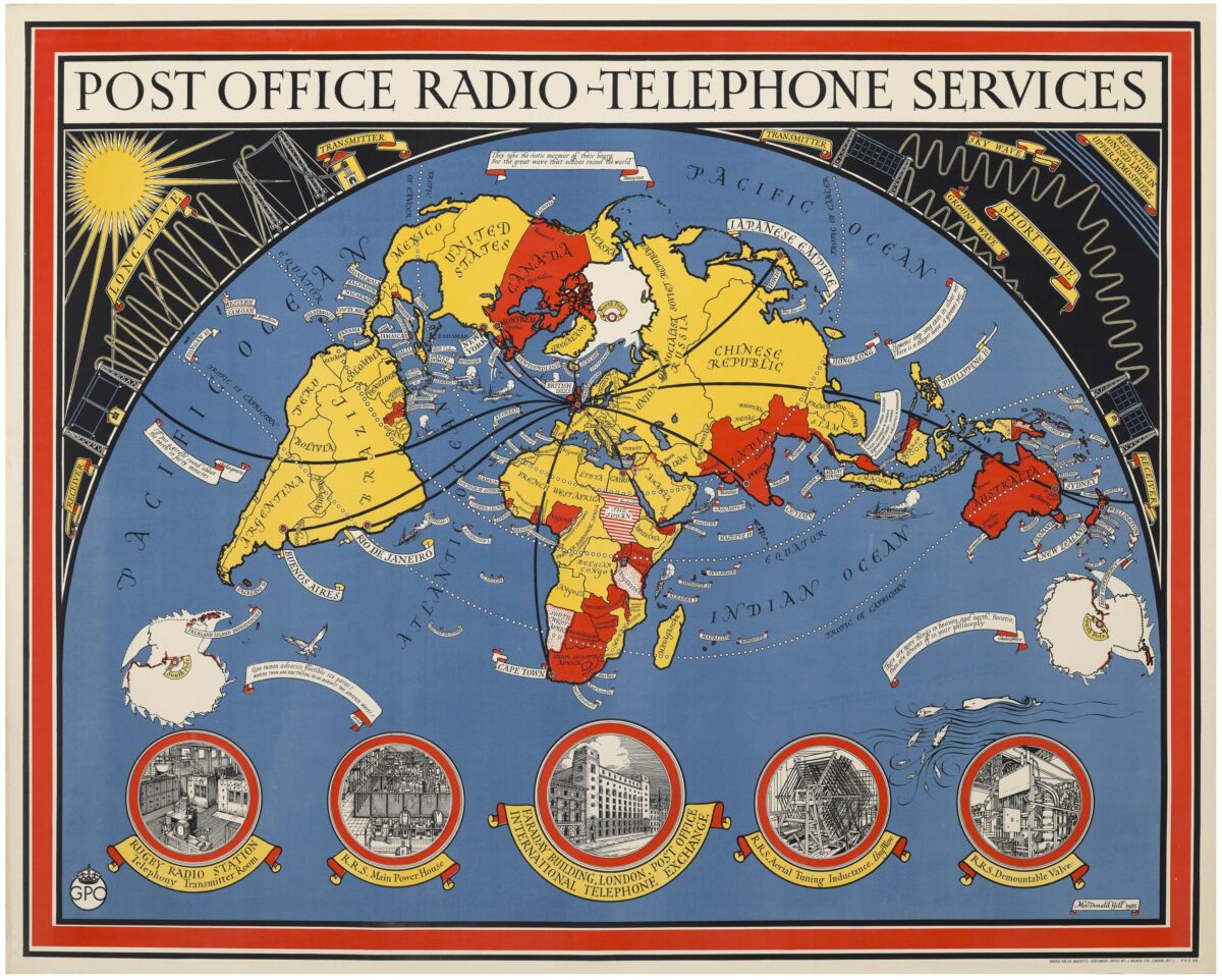
This 1935 map showing ‘Post Office Radio-Telephone services’ by illustrator and cartographer Macdonald Gill shows the General Post Office’s global network of wireless two-way voice connections. The map is a lithograph print designed for the Post Office and printed by J. Weimer Ltd.
The Boston Rare Maps inventory shares the following information:
The poster features a stripped-down world map on an unusual projection and centered on the Great Britain, with the GPO’s network of radio telephone connections extending spiderlike to every continent but Antarctica. The design is marked by functional and decorative elements typical of Gill’s style, in particular the use of vivid color, bold and imaginative typography, and above all the extensive use of illustrations. Some of these—such as the sun at upper left and the vessels plying the oceans—are entirely decorative. Others, such as the diagrams of transmitters and wavelengths across the top, and the illustrations of radio telephone facilities below, are decorative and instructional, while also promoting the organizational might and technical prowess of the GPO.
The General Post Office and wireless telegraphy
Broadly speaking, Charles I was the first to grant the Post Office a monopoly on mail delivery in England, a monopoly extended to all of Great Britain by Oliver Cromwell in 1657. The monopoly endured, and when telecommunications technologies emerged in the 19th century the GPO wasted little time in extending its reach:
“[The] GPO claimed monopoly rights on the basis that like the postal service they involved delivery from a sender and to a receiver. The theory was used to expand state control of the mail service into every form of electronic communication possible on the basis that every sender used some form of distribution service. These distribution services were considered in law as forms of electronic post offices. This applied to telegraph and telephone switching stations.” (Wikipedia)
Thus, when the British government decided after the First World War to construct the “Imperial Wireless Chain” connect its global empire, control was assigned to the GPO. In 1926 Rugby Radio Station was opened in Warwickshire, its first transmitter installed to send telegraph messages. Soon a second transmitter was installed for sending radio telephone messages, and on January 7, 1927 commercial service was opened between London and New York.
By the 1930s the GPO was a global telecomms colossus and, not coincidentally, a pioneer in marketing communications. “Following criticism of the organisation in the 1920s for its conservative use of publicity, the GPO embarked upon a series of creative publicity campaigns that applied, amongst other methods, advertising, public relations, promotions, cinema, events and artistic posters.” (Michael Heller, “The Development of Integrated Marketing Communications at the British General Post Office, 1931-39”, Business History, vol. 58 no. 7 (2016), abstract.) Among other things, the GPO commissioned MacDonald Gill to design three spectacular posters: the one offered here (1935), “Mail Steamship Routes” (1937), and “Post Office Wireless Stations” (1939). Previously, in 1934, Gill had designed the GPO’s new logo, which is visible on this “Radio-Telephone Services” poster at lower left.
MacDonald (“Max”) Gill (1884-1947)
Gill was born in Brighton, England, the second son among a total of 13 children (His elder brother, Eric Gill, was an artist and a significant figure in the Arts & Crafts movement.) His family moved to Chichester, where Gill went to school before a brief apprenticeship with a local architect. Around 1903 he moved to London, and for several years worked as an assistant to an ecclesiastical architecture firm in London, while also taking classes at the Central School of Art, where he was deeply influenced by the thriving Arts & Crafts movement. In 1908 he went into independent practice. Though best known as a designer of pictorial maps, throughout his career Gill took a wide range of architectural, mural and even type-design commissions. In 1918, for example, the Imperial War Graves Commission engaged him to design the alphabet for military badges and headstones, still in use today.
Gill’s first cartographic project of which I have found mention came in 1909, being a “wind-dial” commissioned by the architect of a villa in Buckinghamshire. In 1913 he was commissioned to produce a promotional map poster for the Underground Electric Railways of London. The resulting “Wunderground Map of London Town” was a hit, and he became a “go-to” artist for major pictorial maps such as those issued by the Empire Marketing Board and Cable and WirelessPLC. But the “Wunderground Map” also marked a broader trend, “herald[ing] the use of pictorial maps in the world of commercial publicity” (“Biography” at macdonaldgill.com). Gill produced many such maps over the course of his career, as well as painted maps for private commissions, though none so famous today as the “Wunderground Map”. His final map was the spectacular 1946 “Cable & Wireless Great Circle Map”, produced in 1946, less than a year before his death.
Shared by Dr Chris Mourant, Lecturer in Early 20th Century English Literature